Appalachian Trail Thru-Hike
Appalachian Trail Thru-Hike
May 2002 - Nov 2002
May 2002 - Nov 2002
FRONT PAGE
JOURNAL
PACK & GEAR
PLANNING
AT FAQs
AT LINKS
Appalachian Trail Sections
N.C./GA >
TENN/N.C. >
S.W. VA >
CENTRAL VA >
SHENANDOAH >
WV/N.VA >
MD/PA >
NJ >
NY >
CT >
MA >
VT >
NH >
ME >
GEORGIA & N.CAROLINA
SECTION OVERVIEW
S. BOUNDARY
0
N. BOUNDARY
163.5
TOTAL MILES
163.5
SECTION POST OFFICES
Suches, GA 30572
20.0
Hiawassee, GA 30546
66.8
Franklin, NC 28734
106.8
Fontana Dam, NC 28733
161.7
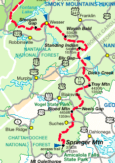
SECTION MAP
SECTION FEATURES
Springer Mt
3782 ft
Blood Mt
4458 ft
Standing Indian Mt
5490 ft
Wayah Bald
5342 ft
SHELTERS/TOWNS
Springer Mountain Shelter
0.2
Stover Creek Shelter
2.5
Hawk Mountain Shelter
7.6
Gooch Mountain Shelter
14.7
Gooch Gap Shelter
16.1
SUCHES, GA 30572
20.0
Woods Hole Shelter
26.6
Blood Mountain Shelter
28.3
Whitley Gap Shelter
36.9
Low Gap Shelter
41.3
Blue Mountain Shelter
48.5
Tray Mountain Shelter
56.2
Deep Gap Shelter
63.3
HIAWASSEE, GA 30546
66.8
Plumorchard Gap Shelter
71.1
Muskrat Creek Shelter
78.4
Standing Indian Shelter
83.3
Carter Gap Shelter
90.9
Big Spring Shelter
97.7
Rock Gap Shelter
103.0
FRANKLIN, NC 28734
106.8
Siler Bald Shelter
110.5
Cold Spring Shelter
122.6
Wesser Bald Shelter
128.4
A. Rufus Morgan Shelter
133.3
Sassafras Gap Shelter
141.0
Brown Fork Gap Shelter
150.1
Cable Gap Shelter
156.2
FONTANA DAM, NC 28733
161.7
Fontana Dam Shelter
162.8
N.C./GA >
TENN/N.C. >
S.W. VA >
CENTRAL VA >
SHENANDOAH >
WV/N.VA >
MD/PA >
NJ >
NY >
CT >
MA >
VT >
NH >
ME >
© 2002 Tony Pisarra
[
Top ^
]
Home
|
Journal
|
Planning
|
Pack & Gear
|
FAQ
|
Links
© Sophiaknows.Com